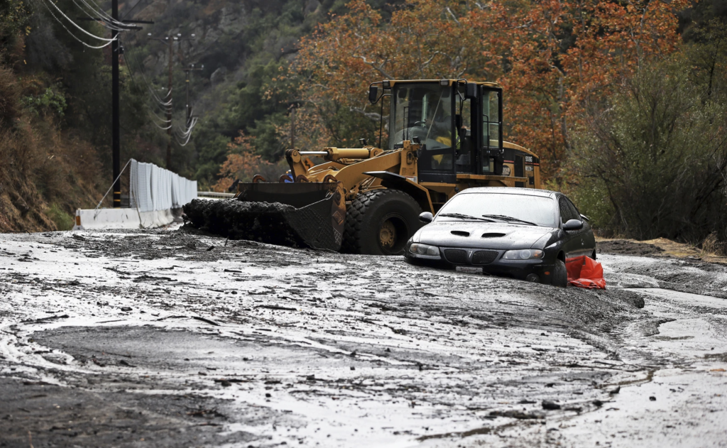
An evacuation order for Santa Maria Rd North of Topanga Canyon was issued last night instructing residents to “LEAVE IMMEDIATELY” as authorities believe there is an immediate threat to life. The area is lawfully closed to public access.
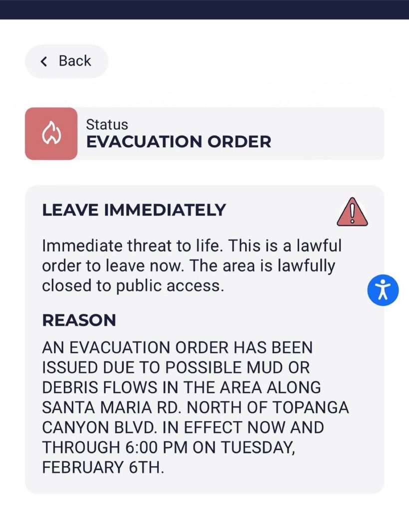
The order reads as follows:
“AN EVACUATION ORDER HAS BEEN ISSUED DUE TO POSSIBLE MUD OR DEBRIS FLOWS IN THE AREA ALONG SANTA MARIA RD. NORTH OF TOPANGA CANYON BLVD. IN EFFECT NOW AND THROUGH 6:00 PM ON TUESDAY, FEBRUARY 6TH.”
Red Cross shelter for Owen fire debris evacuees: ONE Generation18255 Victory Blvd, Reseda CA 91335800-675-5799Evacuation center for animals:Agoura Animal Care Center. 29525 Agoura Road, Agoura CA 91301.
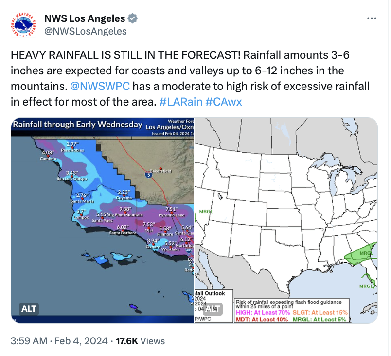
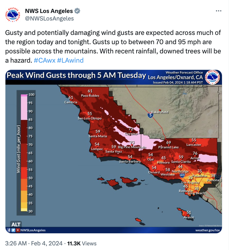
The National Weather Service has been prediciting devastating and potential life threatening conditions for the last week. These are the latest prediction posted on X :
On Sunday, February 4, 2024, 6:00 AM PST, meteorologist Jason Daniel Farhang posted what to expect of the upcoming storm:
“A powerful unprecedented 975 mb low is located just 125 miles off Lompoc, CA. Damaging southerly surface winds have begun across the Central Coast to Santa Barbara counties.
Reports of wind gusts knocking out larger trees arrived at 3:00 AM. The main atmospheric river and the plume of moisture axis are heading right into Santa Maria to Lompoc, CA. Central California and San Jose have been experiencing heavy to moderate rainfall in the last 8 hours.
Rainfall amounts so far have reached over 2 inches of rain with damaging winds of 45MPH – 75 MPH. The atmospheric river plume is expected to slam Santa Barbara by no later than 11 PM. A low-pressure system originating from Tonga is combined with a surface cold front and a tropical airmass, leading to an orographic lift over San Marcos Pass and the San Ynez Mountain range. This is producing rainfall rates of 1.5 to 2 inches per hour later this afternoon by 2 PM.
Santa Barbara and Ventura Counties will be affected until 10 PM. This axis of the atmospheric river plume will shift directly over Los Angeles County and expand into Santa Barbara Counties on Monday midday to Tuesday evening, creating a stalled atmospheric river scenario event that hasn’t been seen in an extremely long time.
There will be a significant and dangerous flood situation for 18 to 25 hours. This type of storm, with tropical moisture combined with damaging winds of 45 to 75 mph gusts has not been seen in this region due to proximity of the surface low within 120 miles of Channel Islands with this severity and intensity for over 30 years.
Projected rainfall amounts of 5.4 inches to 10.8 inches are trending and accompanied by severe thunderstorms that produce locally even higher rainfall intensities and possible convective tornado parameters along the coastal zones from Santa Barbara to San Diego.
The southern extent of the atmospheric river will move into Orange County San Diego, Riverside, and San Bernardino counties by late Tuesday, bringing extremely heavy rainfall amounts as well as significant flood issues.”
More updates on conditions in the area as the storm develops.


Leave a Reply